|
|
|
This page last updated on 01/26/2019. Copyright © 2001-2019 by Russ Meyer |
In the late 1970's we would often hike the South Fork trail past the canyon where a small plane had crashed (pieces of wreckage could still be seen when the sun was just right), sometimes on past the burned down cabin (only the stone fireplace still stands), and every so often to the summer cabins about 4-5 miles up the trail. If one followed this trail on past the cabins, they would eventually wind up at the top of the Blue Mountains near the watershed. One time we hiked past the burned down cabin and found a place to camp overnight. During the night Zach (then about 1 yr old) started crying and wouldn’t stop no matter what I did, so we decided to pack up and go home. While Willy minded our perpetually jinxed headlamp and finding the trail, I stumbled along behind him barely able to make things out...Zach, of course, had quit crying halfway back to the car. We finally tied a long white shoelace to his backpack for me to keep hold of, and luckily the moon was shining just enough to reflect off the shoelace so I could guess which direction he was taking. When we first started going to the South Fork in the late 1970's and early 1980's there were mainly fishermen using that area. After one reached the main parking lot, only a poorly maintained rocky dirt road continued on for a few hundred feet. If one wanted to go on further, there was a trail to follow. As is the usual sad story with progress, the trail was widened to a road all the way to the log footbridge. Then the road was asphalted over and a small weekend camping area was made for RV’s. Then the log footbridge was rebuilt to accommodate traffic. Then the path past the bridge was widened to a dirt road all the way to the summer cabins (including fords through the river for the 4 wheelers). Then the area at the end of the road quite naturally turned into the perfect place for teenage parties, litterbugs, gang violence, bonfires, drug trafficking, etc. Instead of enjoying the scenery and wildlife, one had to concentrate mostly on dodging trail bikes, 4 wheelers, horse doo, garbage, fire pits, and hordes of pea-brained people that didn’t want to pack it in or out. Finally someone got smart and the road was closed to vehicles a short way beyond the bridge. I haven’t hiked beyond the bridge for a long while now because there’s just too much congestion along the trail. Trucks, horse trailers, and short tempers frequently clog the parking area past the bridge, and it’s become nearly impossible to find a quiet spot for a picnic. I am reminded of how true the old hiking adage is - the higher one goes, the fewer people one sees. Nowadays we stick to a rarely used trail that starts with an uphill scramble near the main parking log and ends dubiously near the parking place past the bridge. Only once or twice have I seen anyone else hiking this trail. One of my favorite spots is a high meadow that requires yet another stiff uphill climb; the only noise up there is the wind and an occasional hawk. In 1976 we hiked up a narrow ravine that bisects this trail and discovered a waterfall and a tiny, grassy meadow perfect for camping and picnicking. 28 years later Zach and I re-visited this area, and the only changes I noted were the growth of the trees and bushes. After all those years, the ravine still seems serene and unvisited - though I always get the feeling that something unseen by us lives up there and watches over the South Fork area. When I die, I want to be cremated and have my ashes scattered in this tiny meadow. July 2004 |
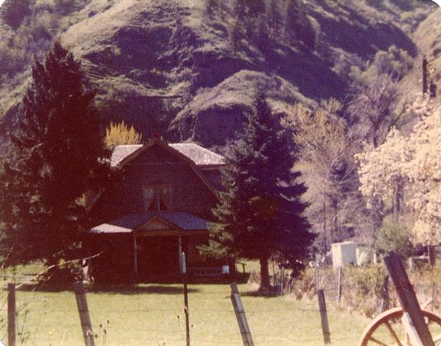 Way up the South Fork road there is an old 2 story stone house that I just
love - it’s one of those places that looks like it must have grown out of the
ground and was meant to be there all along because it blends in so well with the
surroundings. I’m guessing it was built in the late 1800's or early 1900's from
the local river rock. In the late 1990's the house was sold and the new owners
added on to it by covering one of the dormers with a poorly constructed addition
that gave no consideration whatsoever to the original stonework. They also cut
down the huge pine trees and apple trees growing around the house. A once unique
and possibly historic house has now become an eyesore; I wish I could afford to
buy it and restore it.
Way up the South Fork road there is an old 2 story stone house that I just
love - it’s one of those places that looks like it must have grown out of the
ground and was meant to be there all along because it blends in so well with the
surroundings. I’m guessing it was built in the late 1800's or early 1900's from
the local river rock. In the late 1990's the house was sold and the new owners
added on to it by covering one of the dormers with a poorly constructed addition
that gave no consideration whatsoever to the original stonework. They also cut
down the huge pine trees and apple trees growing around the house. A once unique
and possibly historic house has now become an eyesore; I wish I could afford to
buy it and restore it.